7 Meuses
| GPS Coordinates | 50.354166667°N 4.86083333°E |
S (135°-225°) |
|---|---|---|
| Usage | Hang Gliding / Paragliding | |
| Flight Type | Vols thermodynamiques (site classique) | |
| Opening dates | 16 March - 16 March | |
| Height take off | 250 m | |
| 165 m |
Général
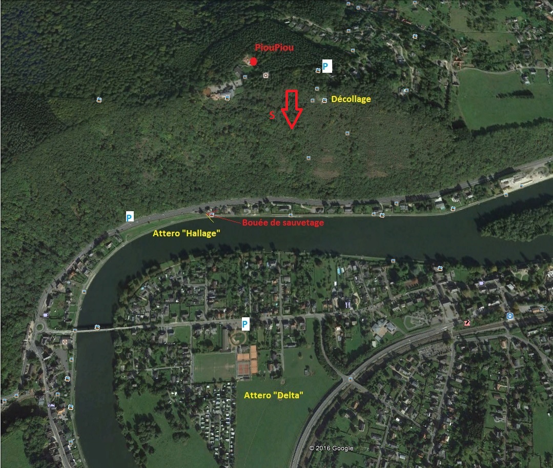
Décollage = start – Attero = landing – Bouée de sauvetage = life buoy
Rules
This site is reserved to the members of the BVVF-FBVL or equivalent foreign federations, holders of a pilot license and insured for their legal liability for hang gliding or paragliding.
Tandem flights are prohibited unless written consent of the BVVF-FBVL.
Landing in the launch area is permitted only when it is cleared. Take-offs have PRIORITY at all times on the launch area, as its name implies. A pilot wishing to land should immediately stop its approach if another pilot prepares for a take-off. The take-off area is the entire area that is located in front of the trees.
Strictly following the rules of priority (paraglider = hang glider !) and adjust your distance with regard to the slope, the antenna and the other pilots depending on the flight conditions. Do not fly "on the spot" and let the other pilots turn in the thermals.
Airspace
This site is located underneath the military TMA of Florennes (from 2500 ft/750 m AMSL), which is active every workday but which can also become active anytime on weekends and holidays. Therefore check the NOTAM’s on the FBVL-website or the Belgocontrol-website. During activation of the TMA, it is forbidden to climb higher than 500 m above the take-off. When the military base is in "stand-by" access to the TMA is allowed only by maintaining a listening watch of Brussels FIC radiofrequency (126,900 MHz).
Less than 4 km to the North, beware of the TMA de Charleroi that is always ACTIVE (from 2500 ft/750 m AMSL West of the river Meuse and from 3500 ft/1050 m AMSL East of the Meuse). Note that 17,5 km NNW of take-off (no CTR), the TMA even descends to 2200 ft/660 m AMSL. One may NEVER penetrate the TMA, and to avoid this one must sidetrack to the East up to the junction between the E411 and N4, staying on the South side of the forest North of Maillen (and of the ultralight-field), which is only possible during weekends and holidays or/and when the TMA Beauvechain 4 (2500-4500 ft AMSL), which begins at this point, is not activated.
Take off
Altitude: 250 m AMSL.
Locality: Viewpoint of the 7-Meuses, Rue du Sart à Soilles, Rivière.
Access & Parking: Leave your vehicle south of the road or at the restaurant (not in front of the houses), drive slowly (children) and respect nature (throw your garbage in the trashcan or take it back home).
Respect the environment and the residents. Drive calmly !
Landing
“Towpath” landing field
Between the Meuse and the 4-lane road, on the right hand side seen from the take-off (field in green on the map). Very small landing with risk of STRONG TURBULENCE. Visiting the landing is IMPERATIVE before flying on this site. The approach is done above the river Meuse, but be careful for downwind. At the same time one must be very wary for changing wind directions on this field.
Altitude : 85 m
Glide ratio: 4
Access and parking: Along the 4-lane road at the foot of the site (see map). Do not park your car along the road on the side of the landing field, on the towpath or the path that leads to the neighbors. There is a parking lot across the road.
“Camping” landing field
The big meadow in front of the take-off, between the campsite and the 2-lane road. It is forbidden to fly over the campsite at a low altitude. Pay attention to the roadside lighting poles.
Paragliding: when the wind is getting stronger, it may be impossible to reach this field, head then to the "towpath" landing field.
Altitude : 85 m
Finesse: 6
Access and parking: at Godinne, cross the river and take the overpass to the right, on top of the viaduct go right.
Dangers
LANDING "camping" (hang gliders and paragliders):
Along the road in the village there is an electricity line that is visible from far, but 1m50 above it lies a deadly semi-high voltage line that is practically invisible.
HANG GLIDING: Simple surfaces: watch out ! The landing area is quite far from the take-off, especially with a sustained South wind. In this case, one must first gain altitude before heading to the landing. If during your first passage in front of the hill you don't gain height, head immediately to the landing field.
PARAGLIDING: Turbulent site by Westerly winds. Pay attention to the strengthening of the wind: don't let yourself drift behind the hill (lee-side turbulence and no emergency landing). DELICATE LANDING FIELD ALONGSIDE THE MEUSE! (See landings chapter: Towpath).
ATTENTION: In the event of flooding of the Meuse, it is strongly discouraged to use the “towpath” landing field. The strong current of water represent under these conditions a mortal danger.


